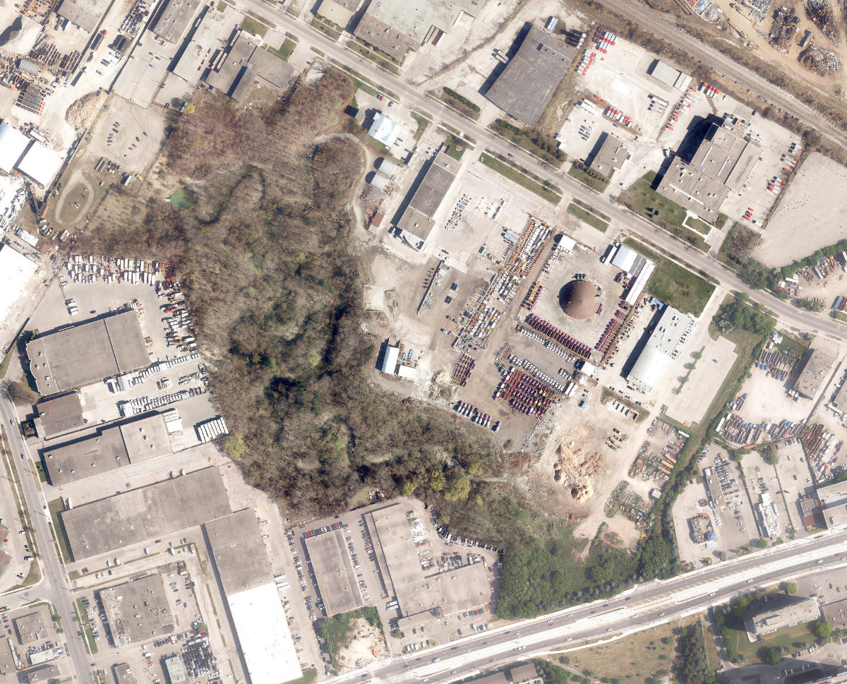
Emery Parks Yard
Ravine / Naturalized Park, below average overall (score 28, rank ~22th percentile). Strongest: natural comfort; weakest: enclosure.
Aerial, City of Toronto orthophoto, ~8 cm/px source · cached 5/9/2026
Emery Parks Yard scores 27.9 / 100. Strongest dimensions: natural comfort and enclosure / eyes on park. Weakest: amenity diversity (0). Border-vacuum risk is elevated (60). This score is a transparent reading of Jane Jacobs-style vitality factors, not a definitive judgment.
Area · 17.82 ha
Weighted across six dimensions · confidence 63%
Scores are not bell-curved. Percentiles and expected scores provide context without changing the underlying model.
Loading map…
The parks map is loading.Explain this score
Where did the 28 come from? Each weighted contribution against a neutral 50 baseline. Green = pushed up; red = pulled down.
Sum of contributions = the headline score. A negative bar means that dimension dragged the park below the city-wide neutral baseline.
Why this park works
Emery Parks Yard works because its natural comfort score (74) is in the top tier (35% tree canopy provides real shade; it sits inside the ravine system).
What limits this park
Emery Parks Yard is held back by enclosure (47, bottom quartile); border-vacuum risk is also elevated (60).
Most distinctive characteristic
Most distinctive feature: exceptionally low enclosure (47, bottom quartile).
Jacobs reading
Emery Parks Yard sits between an urban social park and an ecological retreat: moderately useful for both, exceptionally suited to neither.
Tradeoffs
- Natural comfort (74) significantly outpaces connectivity (41): restorative but hard to reach for daily use.
Performance in context
- Reads as a modest underperformer relative to comparable parks (gap -8; cohort: large Ravine / Naturalized Park ravine).
Typology classification
Classified as Ravine / Naturalized Park: 63% ravine overlap, 35% canopy. Secondary read: Neighbourhood Park (17.8 ha, framed by 5 mid-rise vs 0 towers).
Edge Activation
Within 100 m of the park edge: 13 active uses (retail, transit_stop, restaurant) and 9 dead/hostile uses (parking_lot). Active edges keep "eyes on the park" through the day; parking lots, blank institutional walls, rail and highway frontages drain street life.
Source: OSM POIs (amenity/shop) + Toronto Building Footprints + land use
Connectivity
Connectivity blends paths, intersections, transit, entrances, and edge density. This park has 2 mapped paths/walkways and 9 sidewalk segments within 50 m; 2 street intersections within 100 m; 22 transit stops within a 400 m walk; 0 estimated access points across ~1,953 m of perimeter. low edge density, significant superblock penalty applied. Source coverage: centreline, pedestrian_network, transit_osm.
Source: Toronto Centreline V2 + Pedestrian Network + OSM transit stops
Amenity Diversity
No amenities recorded. Score is 0 until inventory is loaded.
Source: Toronto Parks & Recreation Facilities + OSM amenity tags
Natural Comfort
Natural-comfort components for this park: 35.1% estimated tree canopy; 62.9% inside the ravine system; 2.0% water surface; 42 city-mapped trees inside the polygon (2.4/ha). Reading: ravine-cooled. Source coverage: treed_area, ravine, waterbodies, street_trees. Impervious surface is approximated (Toronto's authoritative layer ships only as a raster GeoTIFF).
Source: Toronto Treed Area + Ravine + Waterbodies + Street Tree Inventory
Enclosure / Eyes on Park
38 buildings within 25 m of the park edge (5 mid-rise, 33 low-rise, 0 tower); avg edge height 5.3 m (~2 floors); 1.9 buildings per 100 m of 1,953 m perimeter (moderate frontage density); edges are barely there or single-storey; no towers immediately adjacent. "Eyes on the park" come strongest from the 5 mid-rise edge buildings.
Source: Toronto 3D Massing (building footprints + heights)
Border Vacuum Risk
Border-vacuum factors within 50 m of the park: parking_lot, parking_lot, parking_lot, parking_lot, parking_lot. Jacobs warned that highways, rail, parking lots and blank institutional edges act as "vacuums" that suppress foot traffic and isolate the park from its neighbourhood.
Source: Toronto Street Centreline (highways) + rail layer + OSM landuse + building footprints
Equity Context
Equity Context requires inputs not yet loaded for this park (Toronto Neighbourhood Profiles). Score is held at a neutral 50 with low confidence. Read with caution.
Source: Toronto Neighbourhood Profiles
Amenities (0)
No amenities recorded for this park.
Nearby active-edge features (80)
- parking lot0 m
- parking lot0 m
- parking lot0 m
- transit stop: 61 Toryork Drive5 m
- retail: Sumin Auto12 m
- retail: AJ Barbering21 m
- retail: A1 Auto Mystery32 m
- retail: Premium Furniture40 m
- parking lot43 m
- parking lot48 m
- transit stop48 m
- parking lot55 m
- retail: DNS Auto61 m
- retail: Beck & Aps Beauty Supply & Salon65 m
- parking lot70 m
- retail: De-Sign & Print70 m
- retail: Seoul Hair Design75 m
- restaurant: De Place Restaurant & Bar83 m
- parking lot90 m
- retail: B.A.S.S. Electronics91 m
- parking lot92 m
- transit stop: Finch Avenue West at Jayzel Drive95 m
- parking lot104 m
- parking lot109 m
- retail: Envy Salon & Spa112 m
- parking lot116 m
- transit stop: 113 Toryork Drive120 m
- parking lot120 m
- retail: Starz Mobile129 m
- transit stop: Toryork Drive at Weston Road131 m
- parking lot134 m
- parking lot135 m
- transit stop: Toryork Drive140 m
- parking lot141 m
- retail: Loves 2 Do Hair Salon142 m
- retail: Lucky Store142 m
- parking lot144 m
- retail: Hothi's Mattress Factory Outlet146 m
- parking lot146 m
- retail: MK Meats & West Indian Grocery150 m
- parking lot151 m
- restaurant: Ali Baba's154 m
- rail: Line 6 Finch West158 m
- rail: Line 6 Finch West159 m
- retail: Cash for Gold Jewellery159 m
- retail: Dynasty Auto Selection163 m
- restaurant: Bun Bo Hue, Pho163 m
- retail: Cleptomania Shoes168 m
- parking lot168 m
- retail: Rafik Hair Salon174 m
- restaurant: Lotus Vegetarian Restaurant175 m
- transit stop: Toryork Drive177 m
- cafe: Bar Comunale Sport181 m
- retail: Rafik Fashion Boutique181 m
- rail: MacTier Subdivision181 m
- restaurant: Malado Sushi181 m
- rail: MacTier Subdivision181 m
- restaurant: George's Bar and Restaurant181 m
- parking lot182 m
- restaurant: Uptown BBQ183 m
- parking lot183 m
- transit stop: Emery184 m
- retail: Mister Safety Shoes184 m
- rail184 m
- rail: MacTier Subdivision184 m
- restaurant: Las Fronteras185 m
- restaurant: Thuy Restaurant185 m
- transit stop: Milvan Drive at Penn Drive South North Side186 m
- retail: Number One Nails & Spa186 m
- parking lot189 m
- restaurant: Pho Dau Bo189 m
- retail: Tech Connection190 m
- retail: Prism Wireless194 m
- parking lot194 m
- rail197 m
- retail: Total Auto Sales198 m
- retail: Finch Main Convenience198 m
- retail: Classic Coin Laundry199 m
- retail: Creative Strategy Design199 m
- cafe: Tim Hortons199 m
Park profile
Five-axis radar across the structural dimensions.
Citywide percentile ranks
Across all Toronto parks in the dataset.
- Overall vitality22th
- Edge activation40th
- Connectivity36th
- Amenity diversity46th
- Natural comfort86th
- Enclosure11th
Most similar parks
Closest in metric space across the five structural dimensions.
- Lower Don ParklandsWaterfront Park26
- Westview GreenbeltRavine / Naturalized Park26
- Scarboro Golf And Country ClubRavine / Naturalized Park33
- City Wide Open SpaceOther33
- City Wide Open SpaceRavine / Naturalized Park32
Most opposite parks
Furthest in metric space. Useful for recognising what kind of park this isn’t.
- ALEX WILSON COMMUNITY GARDEN - Open Green SpaceUrban Plaza59
- Leslie Grove ParkParkette68
- Sonya'S ParkUrban Plaza60
- Bellevue Square ParkCivic Square66
- Market Lane ParkUrban Plaza63
Human activity signals: not available
No activity signals have landed for this park yet. The model has scored its physical form but it can’t yet say how often it’s programmed, photographed, or walked through. See /data-ethics for what we will and will not collect.
Does this score feel accurate?
Your read of Emery Parks Yardmatters. We’re testing whether the model lines up with how people actually use the park. Submissions are stored locally; no account needed.
Tell us how this park feels
We measure structure (canopy, edges, connectivity). You measure feeling. Both matter, and disagreement is itself useful civic data.
What would improve this park?
Generated from the weakest measured dimensions: a starting point, not a prescription.
- Activate the edges: encourage cafés, retail or community uses on the streets that face the park; replace blank or parking-lot edges where possible.
- Add or open more entrances and improve sidewalk continuity around the park. More permeability means more spontaneous use.
- Diversify what people can do in the park (playground, washroom, water, shade, performance, sport, garden): even small additions raise this score.
- Encourage mid-rise, windowed frontages around the park so residents have direct sightlines onto it.
- Mitigate border vacuums (highways, rail, parking) with active programming on the still-permeable edges and treat the hostile edge as a design challenge.
Data sources
- City of Toronto Open Data: Parks (Green Space)Polygon boundaries, official names, types.
- Parks & Recreation FacilitiesInventory of in-park amenities (washrooms, fields, rinks…).
- Toronto Pedestrian NetworkSidewalk segments around and through parks; estimated park entrances.
- Toronto Centreline V2Street segments + intersection nodes near park edges; trails and walkways.
- Toronto 3D MassingBuilding footprints + heights for edge-building counts, frontage density, and tower-in-the-park risk.
- Toronto Treed AreaTree canopy share inside park polygons via stratified-grid sampling.
- Toronto Waterbodies & RiversWater surface inside parks + nearest-water distance for cooling.
- Ravine & Natural Feature ProtectionRavine overlap as a cooling / natural-comfort signal.
- Toronto Street Tree InventoryTree count + density inside park polygons.
- Neighbourhood Profiles(Pending) Equity context proxy.
- OpenStreetMap (Overpass API)Cafés, restaurants, retail, transit stops, parking, highways, rail.