Maria Street Parkette
Urban Plaza, middle of the pack overall (score 31, rank ~36th percentile). Strongest: enclosure; weakest: connectivity.
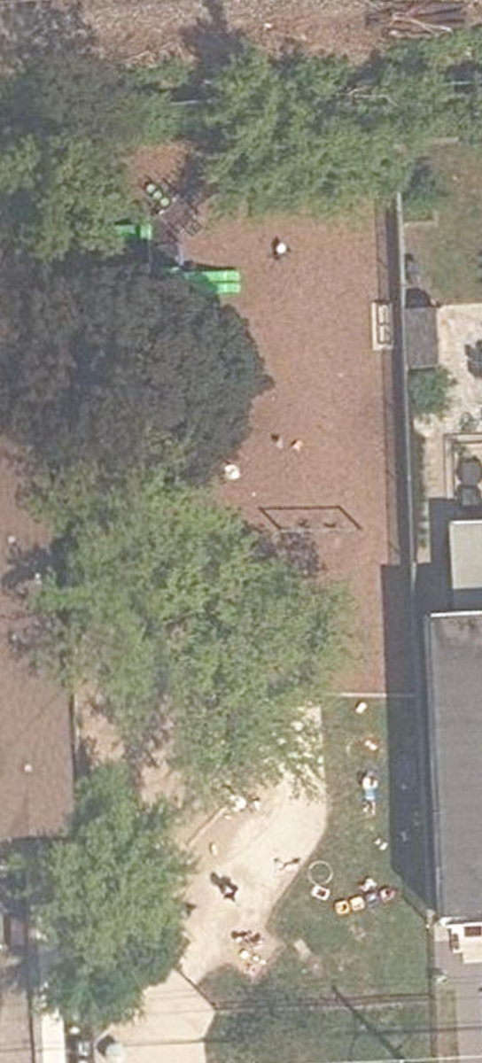
Aerial, City of Toronto orthophoto, ~8 cm/px source · cached 5/9/2026
Maria Street Parkette scores 31.1 / 100. Strongest dimensions: enclosure / eyes on park and natural comfort. Weakest: edge activation (0). Border-vacuum risk is elevated (54). This score is a transparent reading of Jane Jacobs-style vitality factors, not a definitive judgment.
Area · 0.06 ha
Weighted across six dimensions · confidence 66%
Scores are not bell-curved. Percentiles and expected scores provide context without changing the underlying model.
Loading map…
The parks map is loading.Explain this score
Where did the 31 come from? Each weighted contribution against a neutral 50 baseline. Green = pushed up; red = pulled down.
Sum of contributions = the headline score. A negative bar means that dimension dragged the park below the city-wide neutral baseline.
Why this park works
Maria Street Parkette works because its enclosure score (81) is above average and its amenity diversity (12) is also top quartile (3 mid-rise buildings frame the edge with passive surveillance).
What limits this park
Maria Street Parkette's edges are fronted by border-vacuum land uses (highways, rail, parking, blank institutional), risk score 54.
Most distinctive characteristic
Most distinctive feature: exceptionally high enclosure (81, top quartile).
Jacobs reading
Maria Street Parkette sits between an urban social park and an ecological retreat: moderately useful for both, exceptionally suited to neither.
Tradeoffs
- The park is enclosed by buildings (81) but the surrounding streets are quiet (edge activation 0): frame without animation.
Performance in context
- Reads as a modest underperformer relative to comparable parks (gap -5; cohort: pocket Urban Plaza).
Typology classification
Classified as Urban Plaza: 561 m², paved (11% canopy), 31.7 buildings/100 m
Edge Activation
Within 100 m of the park edge: 1 active uses (retail) and 7 dead/hostile uses (rail, parking_lot). Active edges keep "eyes on the park" through the day; parking lots, blank institutional walls, rail and highway frontages drain street life.
Source: OSM POIs (amenity/shop) + Toronto Building Footprints + land use
Connectivity
Connectivity blends paths, intersections, transit, entrances, and edge density. This park has 3 mapped paths/walkways and 0 sidewalk segments within 50 m; 1 street intersections within 100 m; 17 transit stops within a 400 m walk; 1 estimated access points across ~104 m of perimeter. edge density is healthy, no superblock penalty. Source coverage: centreline, transit_osm.
Source: Toronto Centreline V2 + Pedestrian Network + OSM transit stops
Amenity Diversity
1 distinct amenity types in the park (playground). Diversity, not raw count, drives the score so a park with many distinct activity types can outrank a larger park that repeats the same use.
Source: Toronto Parks & Recreation Facilities + OSM amenity tags
Natural Comfort
Natural-comfort components for this park: 11.1% estimated tree canopy; nearest waterbody ~822 m; 3 city-mapped trees inside the polygon (3.0/ha). Reading: exposed. Source coverage: treed_area, waterbodies, street_trees. Impervious surface is approximated (Toronto's authoritative layer ships only as a raster GeoTIFF).
Source: Toronto Treed Area + Ravine + Waterbodies + Street Tree Inventory
Enclosure / Eyes on Park
33 buildings within 25 m of the park edge (3 mid-rise, 30 low-rise, 0 tower); avg edge height 6.8 m (~2 floors); 31.7 buildings per 100 m of 104 m perimeter (strong frontage density); edges are low-rise (mostly 2 to 3 floors); no towers immediately adjacent. "Eyes on the park" come strongest from the 3 mid-rise edge buildings.
Source: Toronto 3D Massing (building footprints + heights)
Border Vacuum Risk
Border-vacuum factors within 50 m of the park: Galt Subdivision, Galt Subdivision, rail. Jacobs warned that highways, rail, parking lots and blank institutional edges act as "vacuums" that suppress foot traffic and isolate the park from its neighbourhood.
Source: Toronto Street Centreline (highways) + rail layer + OSM landuse + building footprints
Equity Context
Equity Context requires inputs not yet loaded for this park (Toronto Neighbourhood Profiles). Score is held at a neutral 50 with low confidence. Read with caution.
Source: Toronto Neighbourhood Profiles
Amenities (1 types · 1 records)
- playground
Nearby active-edge features (51)
- rail: Galt Subdivision34 m
- rail35 m
- rail: Galt Subdivision35 m
- parking lot82 m
- rail84 m
- retail: I’m93 m
- rail99 m
- parking lot99 m
- retail: Coast 2 Coast105 m
- retail: Melo Automotive106 m
- retail: Two Lovely Ladies107 m
- retail: Dundas Print111 m
- retail: Hair Braiding Koo By Chantou112 m
- parking lot116 m
- retail: Lynett Funeral Home116 m
- retail: Wholesale Meat117 m
- retail: Sunny Side Pup Dog Grooming121 m
- retail: Stereo King122 m
- retail: Salon d'Hair124 m
- retail: Hearing & Denture Center126 m
- parking lot126 m
- parking lot127 m
- rail: Galt Subdivision129 m
- retail: Like Honey131 m
- transit stop: Dundas St W at Runnymede Rd133 m
- restaurant: Jumbo Burgers133 m
- transit stop: Maria Street133 m
- retail: High Park Nissan Pre-Owned134 m
- retail: Cornerstone Barber Shop135 m
- retail: My Way Barber Shop136 m
- retail: Metro Vehicles136 m
- rail137 m
- retail: Algrave Auto Clinic139 m
- parking lot139 m
- restaurant: Indilicious141 m
- transit stop: Dundas St W at Runnymede Rd142 m
- transit stop: Dundas Street West153 m
- transit stop: Gilmour Avenue157 m
- transit stop: Dundas Street West158 m
- transit stop: Runnymede Loop160 m
- parking lot163 m
- transit stop: Gilmour Avenue164 m
- retail: La Lavender Salon165 m
- parking lot165 m
- transit stop: Dundas St W at Runnymede Rd174 m
- cafe: Malta Bake Shop177 m
- parking lot179 m
- retail: Rikki179 m
- parking lot189 m
- retail: ABB194 m
- retail: Log Books Unlimited194 m
Park profile
Five-axis radar across the structural dimensions.
Citywide percentile ranks
Across all Toronto parks in the dataset.
- Overall vitality36th
- Edge activation45th
- Connectivity40th
- Amenity diversity81th
- Natural comfort60th
- Enclosure84th
Most similar parks
Closest in metric space across the five structural dimensions.
- Cudmore Creek ParkRavine / Naturalized Park37
- Long Branch ParkWaterfront Park33
- EARL BEATTY COMMUNITY CENTRE - Building GroundsParkette36
- Harlandale ParketteUrban Plaza36
- Pelham Avenue PlaygroundUrban Plaza36
Most opposite parks
Furthest in metric space. Useful for recognising what kind of park this isn’t.
- Leslie Grove ParkParkette68
- Kew GardensNeighbourhood Park71
- ALEX WILSON COMMUNITY GARDEN - Open Green SpaceUrban Plaza59
- Market Lane ParkUrban Plaza63
- Bellevue Square ParkCivic Square66
Human activity signals: not available
No activity signals have landed for this park yet. The model has scored its physical form but it can’t yet say how often it’s programmed, photographed, or walked through. See /data-ethics for what we will and will not collect.
Does this score feel accurate?
Your read of Maria Street Parkettematters. We’re testing whether the model lines up with how people actually use the park. Submissions are stored locally; no account needed.
Tell us how this park feels
We measure structure (canopy, edges, connectivity). You measure feeling. Both matter, and disagreement is itself useful civic data.
What would improve this park?
Generated from the weakest measured dimensions: a starting point, not a prescription.
- Activate the edges: encourage cafés, retail or community uses on the streets that face the park; replace blank or parking-lot edges where possible.
- Add or open more entrances and improve sidewalk continuity around the park. More permeability means more spontaneous use.
- Diversify what people can do in the park (playground, washroom, water, shade, performance, sport, garden): even small additions raise this score.
- Mitigate border vacuums (highways, rail, parking) with active programming on the still-permeable edges and treat the hostile edge as a design challenge.
Data sources
- City of Toronto Open Data: Parks (Green Space)Polygon boundaries, official names, types.
- Parks & Recreation FacilitiesInventory of in-park amenities (washrooms, fields, rinks…).
- Toronto Pedestrian NetworkSidewalk segments around and through parks; estimated park entrances.
- Toronto Centreline V2Street segments + intersection nodes near park edges; trails and walkways.
- Toronto 3D MassingBuilding footprints + heights for edge-building counts, frontage density, and tower-in-the-park risk.
- Toronto Treed AreaTree canopy share inside park polygons via stratified-grid sampling.
- Toronto Waterbodies & RiversWater surface inside parks + nearest-water distance for cooling.
- Ravine & Natural Feature ProtectionRavine overlap as a cooling / natural-comfort signal.
- Toronto Street Tree InventoryTree count + density inside park polygons.
- Neighbourhood Profiles(Pending) Equity context proxy.
- OpenStreetMap (Overpass API)Cafés, restaurants, retail, transit stops, parking, highways, rail.