Runnymede Park
Athletic / Recreation Park, above average overall (score 40, rank ~73th percentile). Strongest: amenity diversity; weakest: edge activation.
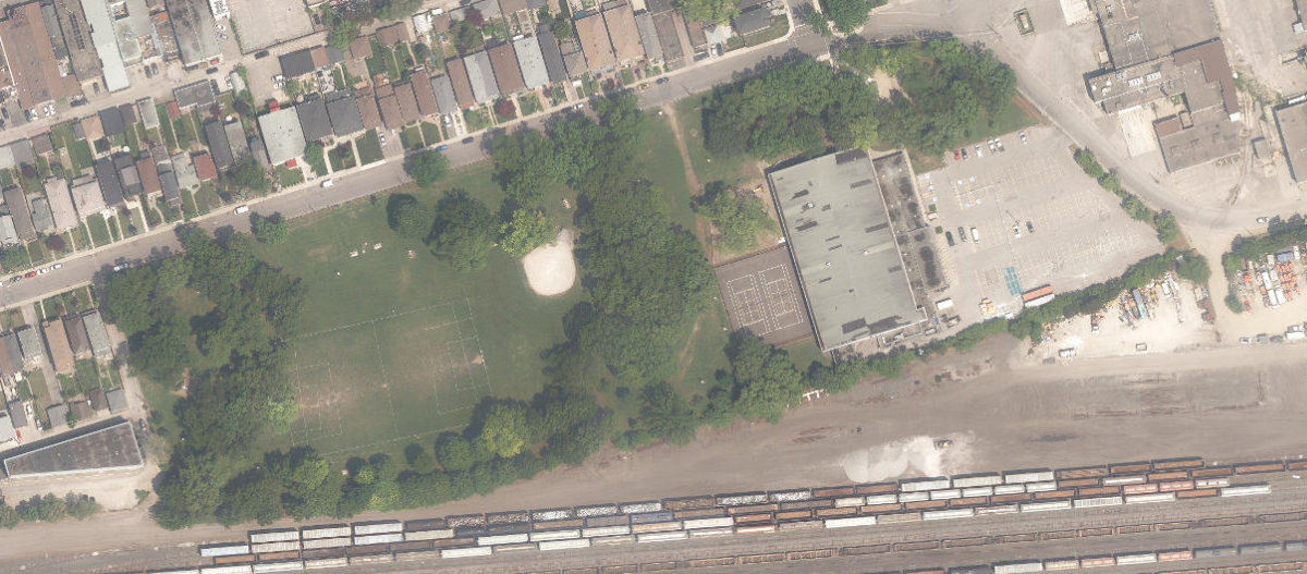
Aerial, City of Toronto orthophoto, ~8 cm/px source · cached 5/9/2026
Runnymede Park scores 39.5 / 100. Strongest dimensions: enclosure / eyes on park and connectivity. Weakest: edge activation (0). Border-vacuum risk is low. This score is a transparent reading of Jane Jacobs-style vitality factors, not a definitive judgment.
Area · 4.52 ha
Weighted across six dimensions · confidence 68%
Scores are not bell-curved. Percentiles and expected scores provide context without changing the underlying model.
Loading map…
The parks map is loading.Explain this score
Where did the 40 come from? Each weighted contribution against a neutral 50 baseline. Green = pushed up; red = pulled down.
Sum of contributions = the headline score. A negative bar means that dimension dragged the park below the city-wide neutral baseline.
Why this park works
Runnymede Park works because its amenity diversity score (28) is in the top tier and its connectivity (57) is also above-average.
What limits this park
Runnymede Park is held back by edge activation (0, below-average): the surrounding streets carry too few active uses to spill into the park.
Most distinctive characteristic
Most distinctive feature: exceptionally high amenity diversity (28, top decile).
Jacobs reading
Runnymede Park sits between an urban social park and an ecological retreat: moderately useful for both, exceptionally suited to neither.
Tradeoffs
- The park is enclosed by buildings (66) but the surrounding streets are quiet (edge activation 0): frame without animation.
Performance in context
- Citywide rank is high (73rd) but typology rank is more modest (24th): the strength likely comes from the dataset average pulling lower than this typology’s baseline.
Typology classification
Classified as Athletic / Recreation Park: 67% of amenity types are athletic (sports_field, tennis). Secondary read: Neighbourhood Park (4.5 ha, framed by 6 mid-rise vs 0 towers).
Edge Activation
Within 100 m of the park edge: 0 active uses (none) and 19 dead/hostile uses (rail, parking_lot). Active edges keep "eyes on the park" through the day; parking lots, blank institutional walls, rail and highway frontages drain street life.
Source: OSM POIs (amenity/shop) + Toronto Building Footprints + land use
Connectivity
Connectivity blends paths, intersections, transit, entrances, and edge density. This park has 0 mapped paths/walkways and 15 sidewalk segments within 50 m; 6 street intersections within 100 m; 26 transit stops within a 400 m walk; 2 estimated access points across ~1,010 m of perimeter. moderate edge density, small superblock penalty applied. Source coverage: centreline, pedestrian_network, transit_osm.
Source: Toronto Centreline V2 + Pedestrian Network + OSM transit stops
Amenity Diversity
3 distinct amenity types in the park (playground, sports_field, tennis). Diversity, not raw count, drives the score so a park with many distinct activity types can outrank a larger park that repeats the same use.
Source: Toronto Parks & Recreation Facilities + OSM amenity tags
Natural Comfort
Natural-comfort components for this park: ~23.4% effective canopy (0.0% from contiguous tree polygons + scattered tree density); nearest waterbody ~662 m; 151 city-mapped trees inside the polygon (33.4/ha). Reading: exposed. Source coverage: waterbodies, street_trees. Impervious surface is approximated (Toronto's authoritative layer ships only as a raster GeoTIFF).
Source: Toronto Treed Area + Ravine + Waterbodies + Street Tree Inventory
Enclosure / Eyes on Park
93 buildings within 25 m of the park edge (6 mid-rise, 87 low-rise, 0 tower); avg edge height 5.8 m (~2 floors); 9.2 buildings per 100 m of 1,010 m perimeter (strong frontage density); edges are barely there or single-storey; no towers immediately adjacent. "Eyes on the park" come strongest from the 6 mid-rise edge buildings.
Source: Toronto 3D Massing (building footprints + heights)
Border Vacuum Risk
Border-vacuum factors within 50 m of the park: parking_lot, parking_lot. Jacobs warned that highways, rail, parking lots and blank institutional edges act as "vacuums" that suppress foot traffic and isolate the park from its neighbourhood.
Source: Toronto Street Centreline (highways) + rail layer + OSM landuse + building footprints
Equity Context
Equity Context requires inputs not yet loaded for this park (Toronto Neighbourhood Profiles). Score is held at a neutral 50 with low confidence. Read with caution.
Source: Toronto Neighbourhood Profiles
Amenities (3 types · 3 records)
- playground
- sports field
- tennis
Nearby active-edge features (69)
- parking lot0 m
- parking lot38 m
- rail56 m
- parking lot58 m
- rail67 m
- rail68 m
- rail: Galt Subdivision71 m
- rail72 m
- rail77 m
- rail: Galt Subdivision79 m
- rail80 m
- rail80 m
- parking lot82 m
- rail82 m
- rail87 m
- rail89 m
- rail: Galt Subdivision90 m
- parking lot98 m
- parking lot99 m
- retail: Silver Automotive Repairs Ltd.101 m
- retail: West Toronto Auto103 m
- rail105 m
- retail: Auto Collisions 7106 m
- retail: Eagle Autowerks108 m
- retail: St. Clair Cannabis108 m
- community: Luso Canadian Charitable Society109 m
- retail: Ahon Auto Parts110 m
- retail: Anti-Oxidant Water Shop110 m
- retail: Ken Shaw Toyota Pre-Owned Centre110 m
- retail: On the Run111 m
- retail: Rally Auto Repair111 m
- retail: Jansu Jan Designer Studio111 m
- retail: Dufferin Motors & Tires112 m
- retail: San Jose Mexican Foods112 m
- retail113 m
- restaurant: Bairrada Churrasqueira113 m
- community: Islamic Social Services and Resources114 m
- restaurant: The Palms Jerk & Grill115 m
- retail: Atlantis Nails Art116 m
- rail124 m
- rail128 m
- cafe: The Stockyards Grind144 m
- transit stop: Symes Road145 m
- retail: Auto Moon151 m
- parking lot156 m
- parking lot164 m
- restaurant: Miss Pho Express166 m
- retail: A&I Automotive Inc.167 m
- retail: Tay Ha Hair Salon168 m
- retail: Ken Shaw Lexus171 m
- restaurant: Bigger’s Restaurant172 m
- retail: Admiral Automotive Service & Tire Centre172 m
- restaurant: Tan Dinh Quan Vietnamese Cuisine178 m
- retail: Lifestyle Beauty Salon180 m
- retail: King of Fades Barbers182 m
- parking lot184 m
- transit stop: Maria Street185 m
- parking lot186 m
- parking lot186 m
- restaurant: Sicily Pizza190 m
- retail: High Park Nissan Pre-Owned190 m
- restaurant: Jumbo Burgers190 m
- transit stop190 m
- parking lot192 m
- restaurant: Las San Sivar195 m
- transit stop: St. Clair Avenue West197 m
- retail: I’m197 m
- transit stop: St. Clair Avenue West199 m
- retail: Melo Automotive199 m
Park profile
Five-axis radar across the structural dimensions.
Citywide percentile ranks
Across all Toronto parks in the dataset.
- Overall vitality73th
- Edge activation35th
- Connectivity69th
- Amenity diversity94th
- Natural comfort67th
- Enclosure62th
Most similar parks
Closest in metric space across the five structural dimensions.
- Woodborough ParkRavine / Naturalized Park41
- Sir Adam Beck ParkNeighbourhood Park40
- Ruddington ParkOther41
- Seasons ParkAthletic / Recreation Park41
- Roywood ParkAthletic / Recreation Park37
Most opposite parks
Furthest in metric space. Useful for recognising what kind of park this isn’t.
- ALEX WILSON COMMUNITY GARDEN - Open Green SpaceUrban Plaza59
- Market Lane ParkUrban Plaza63
- Ryerson Community ParkUrban Plaza60
- Bernard Avenue Road AllowanceUrban Plaza54
- Manor Community GreenUrban Plaza57
Human activity signals: not available
No activity signals have landed for this park yet. The model has scored its physical form but it can’t yet say how often it’s programmed, photographed, or walked through. See /data-ethics for what we will and will not collect.
Does this score feel accurate?
Your read of Runnymede Parkmatters. We’re testing whether the model lines up with how people actually use the park. Submissions are stored locally; no account needed.
Tell us how this park feels
We measure structure (canopy, edges, connectivity). You measure feeling. Both matter, and disagreement is itself useful civic data.
What would improve this park?
Generated from the weakest measured dimensions: a starting point, not a prescription.
- Activate the edges: encourage cafés, retail or community uses on the streets that face the park; replace blank or parking-lot edges where possible.
- Diversify what people can do in the park (playground, washroom, water, shade, performance, sport, garden): even small additions raise this score.
Data sources
- City of Toronto Open Data: Parks (Green Space)Polygon boundaries, official names, types.
- Parks & Recreation FacilitiesInventory of in-park amenities (washrooms, fields, rinks…).
- Toronto Pedestrian NetworkSidewalk segments around and through parks; estimated park entrances.
- Toronto Centreline V2Street segments + intersection nodes near park edges; trails and walkways.
- Toronto 3D MassingBuilding footprints + heights for edge-building counts, frontage density, and tower-in-the-park risk.
- Toronto Treed AreaTree canopy share inside park polygons via stratified-grid sampling.
- Toronto Waterbodies & RiversWater surface inside parks + nearest-water distance for cooling.
- Ravine & Natural Feature ProtectionRavine overlap as a cooling / natural-comfort signal.
- Toronto Street Tree InventoryTree count + density inside park polygons.
- Neighbourhood Profiles(Pending) Equity context proxy.
- OpenStreetMap (Overpass API)Cafés, restaurants, retail, transit stops, parking, highways, rail.