LAWRENCE HEIGHTS COMMUNITY CENTRE - Building Ground
Urban Plaza, below average overall (score 28, rank ~21th percentile). Strongest: amenity diversity; weakest: edge activation.
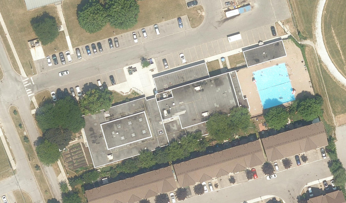
Aerial, City of Toronto orthophoto, ~8 cm/px source · cached 5/9/2026
LAWRENCE HEIGHTS COMMUNITY CENTRE - Building Ground scores 27.8 / 100. Strongest dimensions: enclosure / eyes on park and connectivity. Weakest: edge activation (0). Border-vacuum risk is elevated (100). This score is a transparent reading of Jane Jacobs-style vitality factors, not a definitive judgment.
Area · 0.53 ha
Weighted across six dimensions · confidence 63%
Scores are not bell-curved. Percentiles and expected scores provide context without changing the underlying model.
Loading map…
The parks map is loading.Explain this score
Where did the 28 come from? Each weighted contribution against a neutral 50 baseline. Green = pushed up; red = pulled down.
Sum of contributions = the headline score. A negative bar means that dimension dragged the park below the city-wide neutral baseline.
Why this park works
LAWRENCE HEIGHTS COMMUNITY CENTRE - Building Ground works because its amenity diversity score (12) is above average and its enclosure (74) is also above-average.
What limits this park
LAWRENCE HEIGHTS COMMUNITY CENTRE - Building Ground's edges are fronted by border-vacuum land uses (highways, rail, parking, blank institutional), risk score 100.
Most distinctive characteristic
Most distinctive feature: exceptionally high amenity diversity (12, top quartile).
Jacobs reading
LAWRENCE HEIGHTS COMMUNITY CENTRE - Building Ground sits between an urban social park and an ecological retreat: moderately useful for both, exceptionally suited to neither.
Tradeoffs
- The park is enclosed by buildings (74) but the surrounding streets are quiet (edge activation 0): frame without animation.
Performance in context
- Reads as a modest underperformer relative to comparable parks (gap -11; cohort: small Urban Plaza).
Typology classification
Classified as Urban Plaza: 5348 m², paved (0% canopy), 4.7 buildings/100 m
Edge Activation
Within 100 m of the park edge: 1 active uses (transit_stop) and 11 dead/hostile uses (parking_lot). Active edges keep "eyes on the park" through the day; parking lots, blank institutional walls, rail and highway frontages drain street life.
Source: OSM POIs (amenity/shop) + Toronto Building Footprints + land use
Connectivity
Connectivity blends paths, intersections, transit, entrances, and edge density. This park has 0 mapped paths/walkways and 9 sidewalk segments within 50 m; 7 street intersections within 100 m; 30 transit stops within a 400 m walk; 0 estimated access points across ~338 m of perimeter. edge density is healthy, no superblock penalty. Source coverage: centreline, pedestrian_network, transit_osm.
Source: Toronto Centreline V2 + Pedestrian Network + OSM transit stops
Amenity Diversity
1 distinct amenity types in the park (skatepark). Diversity, not raw count, drives the score so a park with many distinct activity types can outrank a larger park that repeats the same use.
Source: Toronto Parks & Recreation Facilities + OSM amenity tags
Natural Comfort
Natural Comfort requires inputs not yet loaded for this park (Treed Area / Ravine / Waterbodies / Street Trees). Score is held at a neutral 50 with low confidence. Read with caution.
Source: Treed Area / Ravine / Waterbodies / Street Trees
Enclosure / Eyes on Park
16 buildings within 25 m of the park edge (5 mid-rise, 11 low-rise, 0 tower); avg edge height 8.7 m (~3 floors); 4.7 buildings per 100 m of 338 m perimeter (strong frontage density); edges are low-rise (mostly 2 to 3 floors); no towers immediately adjacent. "Eyes on the park" come strongest from the 5 mid-rise edge buildings.
Source: Toronto 3D Massing (building footprints + heights)
Border Vacuum Risk
Border-vacuum factors within 50 m of the park: parking_lot, parking_lot, parking_lot, parking_lot, parking_lot, parking_lot, parking_lot, parking_lot, parking_lot. Jacobs warned that highways, rail, parking lots and blank institutional edges act as "vacuums" that suppress foot traffic and isolate the park from its neighbourhood.
Source: Toronto Street Centreline (highways) + rail layer + OSM landuse + building footprints
Equity Context
Equity Context requires inputs not yet loaded for this park (Toronto Neighbourhood Profiles). Score is held at a neutral 50 with low confidence. Read with caution.
Source: Toronto Neighbourhood Profiles
Amenities (1 types · 1 records)
- skatepark
Nearby active-edge features (35)
- transit stop0 m
- parking lot0 m
- parking lot0 m
- parking lot12 m
- parking lot12 m
- parking lot13 m
- parking lot24 m
- parking lot24 m
- parking lot30 m
- parking lot32 m
- parking lot54 m
- parking lot57 m
- parking lot101 m
- parking lot108 m
- parking lot110 m
- parking lot116 m
- parking lot118 m
- parking lot122 m
- transit stop: Flemington Rd at Varna Dr134 m
- highway: Allen Road137 m
- transit stop: Shermount Avenue138 m
- parking lot140 m
- parking lot148 m
- transit stop: Flemington Rd at Replin Rd149 m
- transit stop: Flemington Rd at Replin Rd152 m
- parking lot155 m
- transit stop: Shermount Avenue159 m
- parking lot163 m
- transit stop164 m
- parking lot172 m
- highway: Allen Road173 m
- parking lot175 m
- parking lot186 m
- transit stop: Varna Dr at Tundra Lane193 m
- transit stop: Varna Dr at Flemington Rd198 m
Park profile
Five-axis radar across the structural dimensions.
Citywide percentile ranks
Across all Toronto parks in the dataset.
- Overall vitality21th
- Edge activation35th
- Connectivity60th
- Amenity diversity76th
- Natural comfort60th
- Enclosure75th
Most similar parks
Closest in metric space across the five structural dimensions.
- Pelham Avenue PlaygroundUrban Plaza36
- MAURICE CODY COMMUNITY CENTRE - Building GroundsNeighbourhood Park37
- Redpath Avenue ParketteCivic Square34
- Cudmore Creek ParkRavine / Naturalized Park37
- Collingwood ParkWaterfront Park27
Most opposite parks
Furthest in metric space. Useful for recognising what kind of park this isn’t.
- Leslie Grove ParkParkette68
- Market Lane ParkUrban Plaza63
- Kew GardensNeighbourhood Park71
- ALEX WILSON COMMUNITY GARDEN - Open Green SpaceUrban Plaza59
- Ryerson Community ParkUrban Plaza60
Human activity signals: not available
No activity signals have landed for this park yet. The model has scored its physical form but it can’t yet say how often it’s programmed, photographed, or walked through. See /data-ethics for what we will and will not collect.
Does this score feel accurate?
Your read of LAWRENCE HEIGHTS COMMUNITY CENTRE - Building Groundmatters. We’re testing whether the model lines up with how people actually use the park. Submissions are stored locally; no account needed.
Tell us how this park feels
We measure structure (canopy, edges, connectivity). You measure feeling. Both matter, and disagreement is itself useful civic data.
What would improve this park?
Generated from the weakest measured dimensions: a starting point, not a prescription.
- Activate the edges: encourage cafés, retail or community uses on the streets that face the park; replace blank or parking-lot edges where possible.
- Diversify what people can do in the park (playground, washroom, water, shade, performance, sport, garden): even small additions raise this score.
- Mitigate border vacuums (highways, rail, parking) with active programming on the still-permeable edges and treat the hostile edge as a design challenge.
Data sources
- City of Toronto Open Data: Parks (Green Space)Polygon boundaries, official names, types.
- Parks & Recreation FacilitiesInventory of in-park amenities (washrooms, fields, rinks…).
- Toronto Pedestrian NetworkSidewalk segments around and through parks; estimated park entrances.
- Toronto Centreline V2Street segments + intersection nodes near park edges; trails and walkways.
- Toronto 3D MassingBuilding footprints + heights for edge-building counts, frontage density, and tower-in-the-park risk.
- Toronto Treed AreaTree canopy share inside park polygons via stratified-grid sampling.
- Toronto Waterbodies & RiversWater surface inside parks + nearest-water distance for cooling.
- Ravine & Natural Feature ProtectionRavine overlap as a cooling / natural-comfort signal.
- Toronto Street Tree InventoryTree count + density inside park polygons.
- Neighbourhood Profiles(Pending) Equity context proxy.
- OpenStreetMap (Overpass API)Cafés, restaurants, retail, transit stops, parking, highways, rail.