Albert Crosland Park
Urban Plaza, middle of the pack overall (score 32, rank ~40th percentile). Strongest: connectivity; weakest: natural comfort.
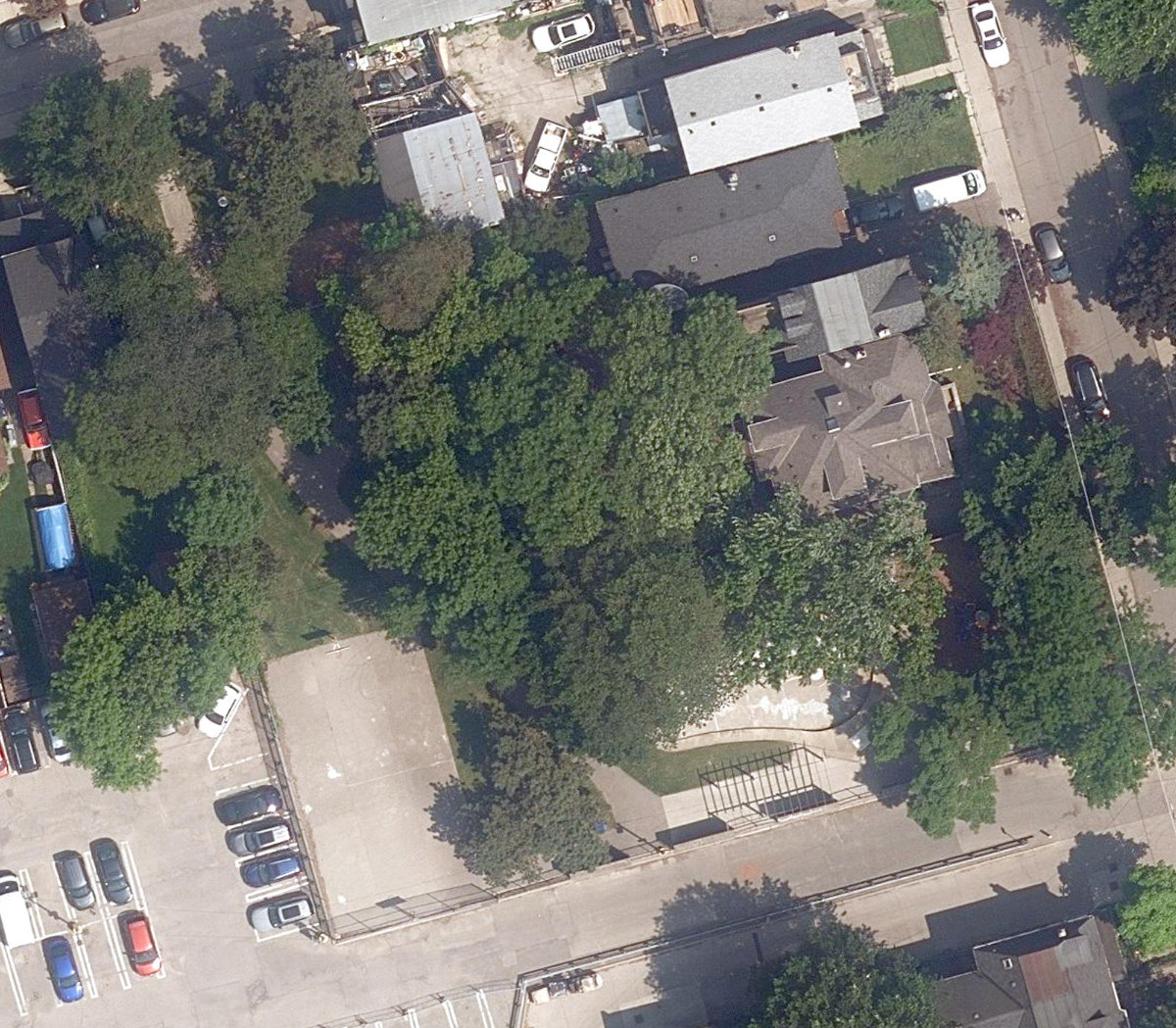
Aerial, City of Toronto orthophoto, ~8 cm/px source · cached 5/9/2026
Albert Crosland Park scores 32 / 100. Strongest dimensions: enclosure / eyes on park and connectivity. Weakest: edge activation (0). Border-vacuum risk is elevated (100). This score is a transparent reading of Jane Jacobs-style vitality factors, not a definitive judgment.
Area · 0.18 ha
Weighted across six dimensions · confidence 66%
Scores are not bell-curved. Percentiles and expected scores provide context without changing the underlying model.
Loading map…
The parks map is loading.Explain this score
Where did the 32 come from? Each weighted contribution against a neutral 50 baseline. Green = pushed up; red = pulled down.
Sum of contributions = the headline score. A negative bar means that dimension dragged the park below the city-wide neutral baseline.
Why this park works
Albert Crosland Park works because its connectivity score (71) is in the top tier and its enclosure (85) is also top decile (21 transit stops sit within a 400 m walk; 15 intersections fall within 100 m of the edge).
What limits this park
Albert Crosland Park is held back by natural comfort (34, bottom quartile): only 0% canopy means little summer shade; border-vacuum risk is also elevated (100).
Most distinctive characteristic
Most distinctive feature: exceptionally high connectivity (71, top decile).
Jacobs reading
Albert Crosland Park sits between an urban social park and an ecological retreat: moderately useful for both, exceptionally suited to neither.
Tradeoffs
- Connectivity (71) significantly outpaces natural comfort (34): well placed in the city but offers little shade or ecological respite.
- The park is enclosed by buildings (85) but the surrounding streets are quiet (edge activation 0): frame without animation.
- High connectivity coexists with high border-vacuum risk (100): much of that connectivity is to highways, rail, or parking lots, not to neighbourhoods.
Typology classification
Classified as Urban Plaza: 1834 m², paved (0% canopy), 38.1 buildings/100 m
Edge Activation
Within 100 m of the park edge: 33 active uses (restaurant, retail, transit_stop, cafe) and 18 dead/hostile uses (parking_lot). Active edges keep "eyes on the park" through the day; parking lots, blank institutional walls, rail and highway frontages drain street life.
Source: OSM POIs (amenity/shop) + Toronto Building Footprints + land use
Connectivity
Connectivity blends paths, intersections, transit, entrances, and edge density. This park has 5 mapped paths/walkways and 14 sidewalk segments within 50 m; 15 street intersections within 100 m; 21 transit stops within a 400 m walk; 4 estimated access points across ~237 m of perimeter. edge density is healthy, no superblock penalty. Source coverage: centreline, pedestrian_network, transit_osm.
Source: Toronto Centreline V2 + Pedestrian Network + OSM transit stops
Amenity Diversity
2 distinct amenity types in the park (basketball, playground). Diversity, not raw count, drives the score so a park with many distinct activity types can outrank a larger park that repeats the same use.
Source: Toronto Parks & Recreation Facilities + OSM amenity tags
Natural Comfort
Natural-comfort components for this park: 0.0% estimated tree canopy; nearest waterbody ~663 m; 1 city-mapped trees inside the polygon (1.0/ha). Reading: exposed. Source coverage: waterbodies, street_trees. Impervious surface is approximated (Toronto's authoritative layer ships only as a raster GeoTIFF).
Source: Toronto Treed Area + Ravine + Waterbodies + Street Tree Inventory
Enclosure / Eyes on Park
90 buildings within 25 m of the park edge (14 mid-rise, 76 low-rise, 0 tower); avg edge height 7.5 m (~3 floors); 38.1 buildings per 100 m of 237 m perimeter (strong frontage density); edges are low-rise (mostly 2 to 3 floors); no towers immediately adjacent. "Eyes on the park" come strongest from the 14 mid-rise edge buildings.
Source: Toronto 3D Massing (building footprints + heights)
Border Vacuum Risk
Border-vacuum factors within 50 m of the park: parking_lot, parking_lot, parking_lot, parking_lot, parking_lot, parking_lot, parking_lot, parking_lot, parking_lot. Jacobs warned that highways, rail, parking lots and blank institutional edges act as "vacuums" that suppress foot traffic and isolate the park from its neighbourhood.
Source: Toronto Street Centreline (highways) + rail layer + OSM landuse + building footprints
Equity Context
Equity Context requires inputs not yet loaded for this park (Toronto Neighbourhood Profiles). Score is held at a neutral 50 with low confidence. Read with caution.
Source: Toronto Neighbourhood Profiles
Amenities (2 types · 2 records)
- basketball
- playground
Nearby active-edge features (80)
- parking lot13 m
- parking lot16 m
- parking lot21 m
- parking lot24 m
- parking lot32 m
- parking lot39 m
- parking lot42 m
- parking lot44 m
- parking lot47 m
- retail: Soepa51 m
- retail: Himalayan Creation51 m
- retail: Frankly,51 m
- retail: Duong Anh Unisex Hair Salon51 m
- retail: Cattleman's Meat Market51 m
- retail: Bernard's Pilipino Specialties51 m
- cafe: Grocery Coffee52 m
- parking lot52 m
- restaurant: Lali Gurans52 m
- retail: Speedy Queen Coin Laundry52 m
- retail: The Sweet Crumble52 m
- restaurant: Mantra52 m
- restaurant: Mezz52 m
- parking lot54 m
- restaurant: Tsampa55 m
- restaurant: Himalayan Kitchen59 m
- retail: Rolda & Owen Unisex Hair Salon & Spa62 m
- parking lot63 m
- parking lot64 m
- restaurant: Thamel Toronto65 m
- parking lot66 m
- parking lot68 m
- retail: Studio Brillantine72 m
- restaurant: Gold Standard72 m
- restaurant: Batibot Filipino Foods and Grocery74 m
- retail: Parkdale Fruit Market77 m
- restaurant: Sun Fa Restaurant77 m
- retail77 m
- retail: Lee's Variety78 m
- parking lot79 m
- parking lot80 m
- restaurant: Forest Hill Farmhouse81 m
- restaurant: Norling83 m
- retail83 m
- parking lot85 m
- restaurant: Afrobeat Kitchen86 m
- restaurant: Jimbu Himalayan90 m
- restaurant: Dave's Hot Chicken92 m
- transit stop: Sorauren Avenue93 m
- retail: Mandala Foodstore94 m
- transit stop: Sorauren Avenue97 m
- cafe: Songtsen Cafe99 m
- retail: Klaxon Howl100 m
- cafe: Tiny Cafe101 m
- retail: New Furniture & Mattress102 m
- retail: AQ Barber & Hairstylist103 m
- retail: Tim's Barber105 m
- parking lot106 m
- restaurant: Garleek Kitchen106 m
- retail: T. Dot Variety Store108 m
- retail: Certified Tire & Auto Service109 m
- restaurant: Momo Café & Zomsa Bar110 m
- parking lot113 m
- transit stop: MacDonell Avenue116 m
- restaurant: Little Tibet119 m
- retail: Letterbox Doughnuts122 m
- retail: Mandala Corner124 m
- restaurant: Parkdale Breakfast127 m
- restaurant: Three Dollar Bill127 m
- parking lot130 m
- retail132 m
- restaurant: A&W132 m
- transit stop: Beaty Avenue135 m
- restaurant: Cici's Pizza137 m
- transit stop: Beaty Avenue138 m
- parking lot139 m
- retail141 m
- parking lot141 m
- parking lot141 m
- retail: The Salvation Army142 m
- parking lot143 m
Park profile
Five-axis radar across the structural dimensions.
Citywide percentile ranks
Across all Toronto parks in the dataset.
- Overall vitality40th
- Edge activation36th
- Connectivity92th
- Amenity diversity89th
- Natural comfort17th
- Enclosure91th
Most similar parks
Closest in metric space across the five structural dimensions.
- Hideaway ParkUrban Plaza42
- Joshua Cronkwright ParketteUrban Plaza37
- Sumach - Shuter ParketteUrban Plaza41
- Margaret Fairley ParkUrban Plaza40
- Northtown ParkUrban Plaza37
Most opposite parks
Furthest in metric space. Useful for recognising what kind of park this isn’t.
- Trca Lands ( 26)Ravine / Naturalized Park27
- Toronto Islands - Muggs Island ParkRavine / Naturalized Park25
- Rouge ParkRavine / Naturalized Park28
- Rouge ParkWaterfront Park25
- Rouge ParkRavine / Naturalized Park26
Human activity signals: not available
No activity signals have landed for this park yet. The model has scored its physical form but it can’t yet say how often it’s programmed, photographed, or walked through. See /data-ethics for what we will and will not collect.
Does this score feel accurate?
Your read of Albert Crosland Parkmatters. We’re testing whether the model lines up with how people actually use the park. Submissions are stored locally; no account needed.
Tell us how this park feels
We measure structure (canopy, edges, connectivity). You measure feeling. Both matter, and disagreement is itself useful civic data.
What would improve this park?
Generated from the weakest measured dimensions: a starting point, not a prescription.
- Activate the edges: encourage cafés, retail or community uses on the streets that face the park; replace blank or parking-lot edges where possible.
- Diversify what people can do in the park (playground, washroom, water, shade, performance, sport, garden): even small additions raise this score.
- Increase canopy and reduce paved area. Shade and water features extend usable hours and seasons.
- Mitigate border vacuums (highways, rail, parking) with active programming on the still-permeable edges and treat the hostile edge as a design challenge.
Data sources
- City of Toronto Open Data: Parks (Green Space)Polygon boundaries, official names, types.
- Parks & Recreation FacilitiesInventory of in-park amenities (washrooms, fields, rinks…).
- Toronto Pedestrian NetworkSidewalk segments around and through parks; estimated park entrances.
- Toronto Centreline V2Street segments + intersection nodes near park edges; trails and walkways.
- Toronto 3D MassingBuilding footprints + heights for edge-building counts, frontage density, and tower-in-the-park risk.
- Toronto Treed AreaTree canopy share inside park polygons via stratified-grid sampling.
- Toronto Waterbodies & RiversWater surface inside parks + nearest-water distance for cooling.
- Ravine & Natural Feature ProtectionRavine overlap as a cooling / natural-comfort signal.
- Toronto Street Tree InventoryTree count + density inside park polygons.
- Neighbourhood Profiles(Pending) Equity context proxy.
- OpenStreetMap (Overpass API)Cafés, restaurants, retail, transit stops, parking, highways, rail.