BEDFORD PARK COMMUNITY CENTRE - Building Grounds
Neighbourhood Park, middle of the pack overall (score 36, rank ~57th percentile). Strongest: enclosure; weakest: natural comfort.
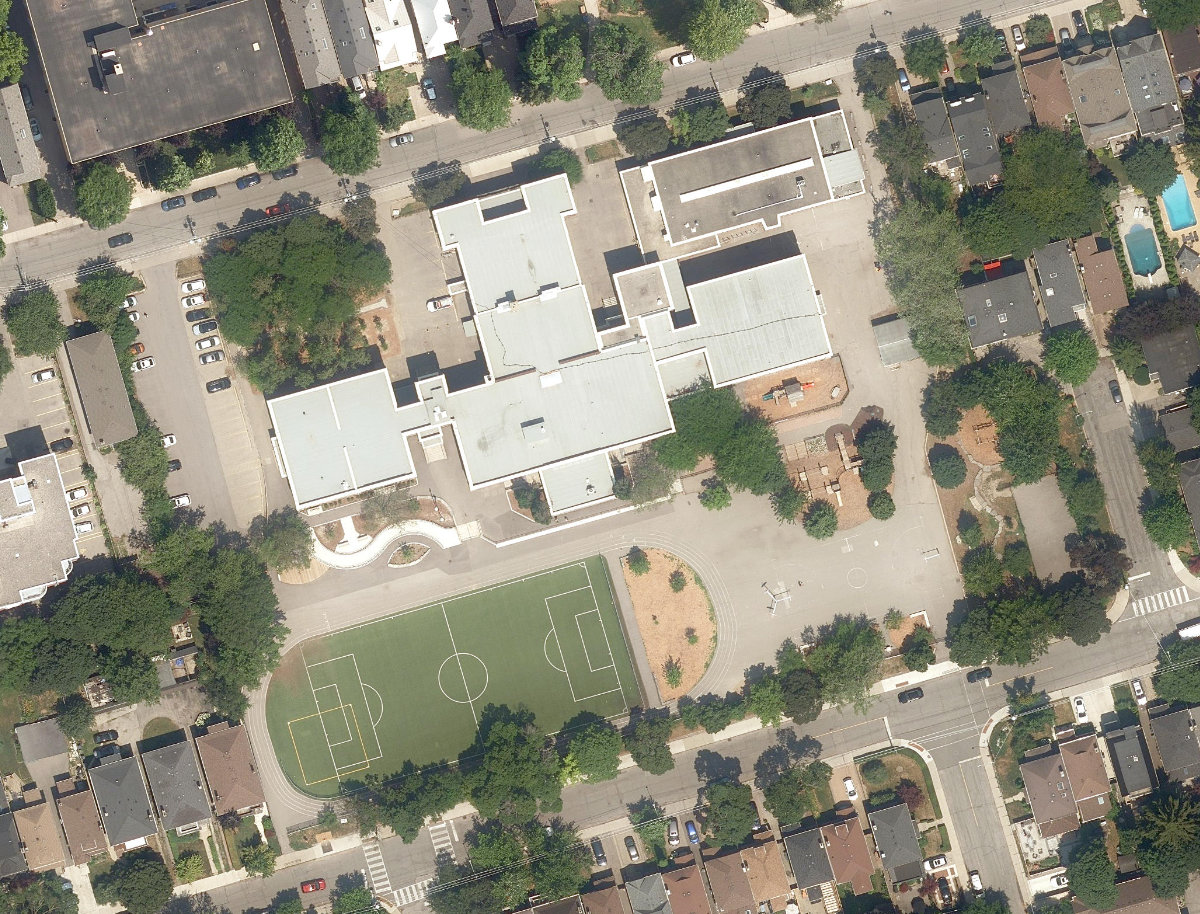
Aerial, City of Toronto orthophoto, ~8 cm/px source · cached 5/9/2026
BEDFORD PARK COMMUNITY CENTRE - Building Grounds scores 35.6 / 100. Strongest dimensions: enclosure / eyes on park and connectivity. Weakest: edge activation (0). Border-vacuum risk is low. This score is a transparent reading of Jane Jacobs-style vitality factors, not a definitive judgment.
Area · 1.61 ha
Weighted across six dimensions · confidence 72%
Scores are not bell-curved. Percentiles and expected scores provide context without changing the underlying model.
Loading map…
The parks map is loading.Explain this score
Where did the 36 come from? Each weighted contribution against a neutral 50 baseline. Green = pushed up; red = pulled down.
Sum of contributions = the headline score. A negative bar means that dimension dragged the park below the city-wide neutral baseline.
Why this park works
BEDFORD PARK COMMUNITY CENTRE - Building Grounds works because its enclosure score (85) is in the top tier and its amenity diversity (12) is also top quartile (26 mid-rise buildings frame the edge with passive surveillance).
What limits this park
BEDFORD PARK COMMUNITY CENTRE - Building Grounds is held back by natural comfort (37, below-average): only 1% canopy means little summer shade.
Most distinctive characteristic
Most distinctive feature: exceptionally high enclosure (85, top decile).
Jacobs reading
BEDFORD PARK COMMUNITY CENTRE - Building Grounds sits between an urban social park and an ecological retreat: moderately useful for both, exceptionally suited to neither.
Tradeoffs
- The park is enclosed by buildings (85) but the surrounding streets are quiet (edge activation 0): frame without animation.
Typology classification
Classified as Neighbourhood Park: 1.6 ha, framed by 26 mid-rise vs 0 towers
Edge Activation
Within 100 m of the park edge: 1 active uses (retail) and 4 dead/hostile uses (parking_lot). Active edges keep "eyes on the park" through the day; parking lots, blank institutional walls, rail and highway frontages drain street life.
Source: OSM POIs (amenity/shop) + Toronto Building Footprints + land use
Connectivity
Connectivity blends paths, intersections, transit, entrances, and edge density. This park has 5 mapped paths/walkways and 11 sidewalk segments within 50 m; 7 street intersections within 100 m; 36 transit stops within a 400 m walk; 0 estimated access points across ~533 m of perimeter. edge density is healthy, no superblock penalty. Source coverage: centreline, pedestrian_network, transit_osm.
Source: Toronto Centreline V2 + Pedestrian Network + OSM transit stops
Amenity Diversity
1 distinct amenity types in the park (community_centre). Diversity, not raw count, drives the score so a park with many distinct activity types can outrank a larger park that repeats the same use.
Source: Toronto Parks & Recreation Facilities + OSM amenity tags
Natural Comfort
Natural-comfort components for this park: ~2.6% effective canopy (0.9% from contiguous tree polygons + scattered tree density); nearest waterbody ~835 m; 6 city-mapped trees inside the polygon (3.7/ha). Reading: exposed. Source coverage: treed_area, waterbodies, street_trees. Impervious surface is approximated (Toronto's authoritative layer ships only as a raster GeoTIFF).
Source: Toronto Treed Area + Ravine + Waterbodies + Street Tree Inventory
Enclosure / Eyes on Park
144 buildings within 25 m of the park edge (26 mid-rise, 118 low-rise, 0 tower); avg edge height 7.8 m (~3 floors); 27.0 buildings per 100 m of 533 m perimeter (strong frontage density); edges are low-rise (mostly 2 to 3 floors); no towers immediately adjacent. "Eyes on the park" come strongest from the 26 mid-rise edge buildings.
Source: Toronto 3D Massing (building footprints + heights)
Border Vacuum Risk
Border-vacuum factors within 50 m of the park: parking_lot, Bedford Park PS staff parking. Jacobs warned that highways, rail, parking lots and blank institutional edges act as "vacuums" that suppress foot traffic and isolate the park from its neighbourhood.
Source: Toronto Street Centreline (highways) + rail layer + OSM landuse + building footprints
Equity Context
Equity Context requires inputs not yet loaded for this park (Toronto Neighbourhood Profiles). Score is held at a neutral 50 with low confidence. Read with caution.
Source: Toronto Neighbourhood Profiles
Amenities (1 types · 1 records)
- community centre
Nearby active-edge features (36)
- parking lot: Bedford Park PS staff parking0 m
- parking lot19 m
- parking lot64 m
- parking lot80 m
- retail: ZayZay Shop85 m
- transit stop: Ranleigh Av Entrance113 m
- retail: See Ya Studio118 m
- restaurant: Pizza Nova118 m
- transit stop: Yonge St at Ranleigh Ave119 m
- retail: Rogers121 m
- transit stop: Mount Pleasant Rd at Wanless Ave133 m
- retail: Parkers Cleaners136 m
- transit stop: Lawrence141 m
- transit stop: Mount Pleasant Rd at Ranleigh Ave145 m
- transit stop: Yonge St at Ranleigh Ave148 m
- transit stop: Bedford Entrance149 m
- transit stop: Lawrence150 m
- retail: Dick Young Market151 m
- restaurant: Pizza Pizza153 m
- highway: Yonge Street154 m
- transit stop: Cardinal Place156 m
- retail: Sleep Country157 m
- parking lot166 m
- transit stop: Mount Pleasant Rd at Ranleigh Ave168 m
- cafe: Second Cup168 m
- transit stop: Weybourne Crescent173 m
- retail: Brading Specialty Shades177 m
- retail178 m
- retail: Snow 1 Hour Cleaners185 m
- transit stop: Mount Pleasant Road188 m
- retail: Dollarama191 m
- cafe: For The Win Board Game Cafe193 m
- retail: Buzzed Buds196 m
- highway: Yonge Street198 m
- restaurant: Maiz Yonge199 m
- transit stop: Yonge St at Lawrence Ave W199 m
Park profile
Five-axis radar across the structural dimensions.
Citywide percentile ranks
Across all Toronto parks in the dataset.
- Overall vitality57th
- Edge activation35th
- Connectivity71th
- Amenity diversity76th
- Natural comfort29th
- Enclosure91th
Most similar parks
Closest in metric space across the five structural dimensions.
- Janda ParkUrban Plaza38
- Alan - Oxford ParketteUrban Plaza38
- Winslow - Dalesford ParketteUrban Plaza38
- Sackville PlaygroundUrban Plaza37
- ST. ALPHONSUS CATHOLIC SECONDARY SCHOOL - Building GroundsParkette36
Most opposite parks
Furthest in metric space. Useful for recognising what kind of park this isn’t.
- Trca Lands ( 26)Ravine / Naturalized Park27
- Toronto Islands - Muggs Island ParkRavine / Naturalized Park25
- Mclevin Woods ParkRavine / Naturalized Park49
- Rouge ParkRavine / Naturalized Park28
- Rouge ParkWaterfront Park25
Human activity signals: not available
No activity signals have landed for this park yet. The model has scored its physical form but it can’t yet say how often it’s programmed, photographed, or walked through. See /data-ethics for what we will and will not collect.
Does this score feel accurate?
Your read of BEDFORD PARK COMMUNITY CENTRE - Building Groundsmatters. We’re testing whether the model lines up with how people actually use the park. Submissions are stored locally; no account needed.
Tell us how this park feels
We measure structure (canopy, edges, connectivity). You measure feeling. Both matter, and disagreement is itself useful civic data.
What would improve this park?
Generated from the weakest measured dimensions: a starting point, not a prescription.
- Activate the edges: encourage cafés, retail or community uses on the streets that face the park; replace blank or parking-lot edges where possible.
- Diversify what people can do in the park (playground, washroom, water, shade, performance, sport, garden): even small additions raise this score.
- Increase canopy and reduce paved area. Shade and water features extend usable hours and seasons.
Data sources
- City of Toronto Open Data: Parks (Green Space)Polygon boundaries, official names, types.
- Parks & Recreation FacilitiesInventory of in-park amenities (washrooms, fields, rinks…).
- Toronto Pedestrian NetworkSidewalk segments around and through parks; estimated park entrances.
- Toronto Centreline V2Street segments + intersection nodes near park edges; trails and walkways.
- Toronto 3D MassingBuilding footprints + heights for edge-building counts, frontage density, and tower-in-the-park risk.
- Toronto Treed AreaTree canopy share inside park polygons via stratified-grid sampling.
- Toronto Waterbodies & RiversWater surface inside parks + nearest-water distance for cooling.
- Ravine & Natural Feature ProtectionRavine overlap as a cooling / natural-comfort signal.
- Toronto Street Tree InventoryTree count + density inside park polygons.
- Neighbourhood Profiles(Pending) Equity context proxy.
- OpenStreetMap (Overpass API)Cafés, restaurants, retail, transit stops, parking, highways, rail.